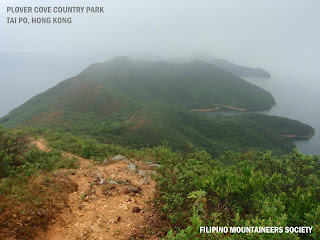
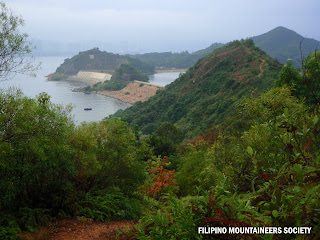
Plover Cove Country Park is a country park in Hong Kong located in the Northeastern New Territories. A large park of 4,594 hectares was designated in 1978, it encompasses contrasting landforms. Meeting the sea on three sides, the park features a range of undulating peaks in the central part. To its west lies Pat Sin Leng Country Park, notorious for dizzying, rugged uplands. Whether you choose to visit Plover Cove on a glorious summer days or spring drizzle the landscape is equally arresting but it is best to venture this trail during cool winter weather of Hong Kong. Anywhere you turn, a seemingly watercolor scenery takes your breath away.
Note: This is the longest hiking trail in Hong Kong, one must be physically fit and able to endure it.
TRANSPO:
Make your way to Tai Po Market KCR Station and board into green mini bus 20C to Wu Kau Tang. On your return to the city just take 275R, 75K or 20C to return at Tai Po Market KCR station.
TRAIL INFO:
- Difficulty - 4/5 (because of its longest trail and because of the original trail made by JB).
- Duration - 6 to 7 Hours
- Terrain - 80% Natural & 20% Man-made modifications (JB Trail: 100% Natural with 85 degrees rock and shrubland climb.
LOGISTICS:
- 25-30 Liter Pack
- 3 Liters Water & 1 Liter of energy drink (summer days).
- 2 Liter Water & 1 Liter of energy drink (spring, autumn & winter).
- Sturdy Hiking Shoes/Boots.
- Light-weight clothing material during summer and some good wind-breaker during the cold season.
- Hiking Pole (Optional)
- Sun Protections (Must be appropriate to the weather on the day of your adventure).
- Navigation Compass & Map (Optional)
- Food/Fruit/Snack
- Portable Camera
- Mobile Phone
- Radio Communication (Optional)
 |
| There's No "Entry Gate" here but this friendly Board Map is at your starting point, follow the red arrow and prepared yourself for a 6-7 hours of adventure...good luck! |
 |
| JB Trail (Here is where you can experience 100% natural trail until you reach the 1st summit close to station post C2602). |
 |
| A view at the summit of "JB TRAIL" (Dramatic landscape covered by fogs during rainy winter season in Hong Kong) |
 |
| The 1st Trigonometric Summit Marker that may encounter at Ma Tau Fung Peak. |
 |
| This is what the trail looks like at 80%...red mud & stones! |
 |
| 2nd Trigonometric Summit Marker. |
 |
| At least 11 kilometers (Approximately 4 Hours) to reach Tai Mei Tuk from this sign board. |
 |
| A very captivating scenery up ahead. This is the most exposed section of the trail. (So stay hydrated during summer) |
 |
| A breath taking piece of island inside the Plover Cove Reservoir. |
 |
| 3rd and last trigonometric summit marker along the trail...have a break here for your final push to reach the Plover Cove Dam. |
 |
| The Plover Cove Dam. |
 |
| There will be an access (stairs) for your exit along the sides of this Dam. (Trail Post Marker C2627-C2628). |
 |
| The last and final Trail Post Marker C2630, proceed to the left side of this route and make your way out towards the metal gate. |
 |
| Exit Point This gate is always open for Hikers and for daily or weekend fishing buddies along the Reservoir. (Bikes are not allowed inside this fencing but outside is). |
 |
| The beautiful Pat Sin Leng Ridge at Dusk (Here is where you can find the Bus Terminal to return to the City) Friendly Reminder Enjoy Your Country Park, Enjoy Hiking and Leave No Trace! |


if anyone of you might wanna try to take the challenge of this terrain...pls be sure that you are physically fit and has acquired hiking experience.
ReplyDeleteHas anyone tried Chi Ma Wan? My friends and I have, but I don't know which one is more difficult. Chi Ma Wan is definitely a longer trail. But the terrain I'm not sure.
ReplyDeleteHi Jinggay...thanks for the lovely comment..well pls let me know your starting point and end point onChi Ma Wan Trail and I will compare the difference between the two. Thanks and hope we can collaborate more on the latest and best trails in Hong Kong. CHEERS!
ReplyDeleteThis comment has been removed by the author.
ReplyDeleteThe reason why Chi Ma Wan is long because the trail is CIRCULAR, unlike Plover Cove Country Park. The trail of Chi Ma Wan Starts and End's at Shap Long Campsite but Plover Cove Starts at Wu Kau Tang and end at Tai Mei Tuk.
ReplyDeleteThanks for the lovely comment and pls keep in touch with the latest development on our outdoor trails in Hong Kong...Cheers!
We're going to Plover Cove next THursday if the weather permits....thanks for the detailed info.
ReplyDelete