Wednesday, November 28, 2012

LOTUS STREAM

Lotus Stream is a 10 km. stream and it would take around 5-6 hours to complete. If your going to do this adventure, you need to make sure that your prepared to get dirty and wet.

TRANSPORTATION:
  • Make your way towards Tsing Yi MTR Station
  • A wide selection of transportation is available from Tsing Yi MTR Station. Take KMB Bus 251M, 263M, 264M, 265M.
  • Alight after 20 mins. ride at Tai Lam Tunnel Bus Station (after crossing the tunnel).
  • At the End Point of the Lotus Stream Trail in Sham Tseng, just get to the Bus stop in front of Rhine Garden and there will be 234A, 52X,63 that will lead you back to Tsuen Wan MTR Station but there are plenty of green mini buses available to take you on your desired destination.
TRAIL INFO:
  •  All Terrain Adventure (Be sure to carry a Dry-Bag to keep your important gear/s not to get wet)
LOGISTICS:
  • 25L - 30L Pack
  • 2L Water
  • 1L Energy Drink
  • Wet Gear (If you wish to dip in natural pool)
  • Dry-Bag (To protect your alternative clothes, phone...etc.)
  • Waterproof Boots
  • Convertible Hiking Pants (1 Extra after getting wet)
  • Light weight shirts (1 Extra after getting wet)
  • Hiking Pole (Optional)
  • Arm Protector (protection from sharp grasses, vines and tree branches)
  • Food/Fruit/Snack
  • Navigation Gear (Map, Compass & 2 Way Radio Communication)
  • Cellular/Mobile Phone (There's a good signal coverage inside the trail)
LET'S GO!


Tsing Yi MTR Station
Leave by taking exit G1 

Quickly after getting off from the escalator, you need to cross this road
and get to the other side to board in to KMB 264M.

KMB Station 264M


After an approximate 20 mins ride from KMB 264M, you need to alight after passing the Tai Lam Tunnel. Make your way down to the staircase, pass under the fly-over and get to this location.

The Mountaineers!

A few seconds of concrete pavement and you will enter the muddy part of the trail. 

A perfect scenery...Mountaineers and vivid Vegetation of the trail.
This is bout 30-40 mins of cruising thru the  muddy trail.

Back to concrete pavement once again.


Make your way to the left and you will begin your journey through stones and water. 

Starting Area of Lotus Stream.
Get thru the trees and you will instantly see the stream and hike all the way up stream.


The White Lotus Pool
(Take a dip if you must!)

Red Lotus Cliff

Rainbow Fall
15 meters in height and it is rather easy and safe to pass around and get to the top of the waterfall.

Lotus Terrace Fall
Quite deep so you can really jump into it... just be sure to calculate your drop zone.

Hidden Valley Of Fairy Lotus
A fascinating but rather shallow waterfall area. There a muddy path along the side of this waterfall and you will need to hike uphill to see the last waterfall on top.

Curl Dragon Fall
The last waterfall on this trail and your adventure is almost over, you need to negotiate thru the slippery passage and hike uphill on either Red and Blue Trail Mark. We choose to hike and finish our adventure on the RED markings. When you meet the concrete trail on top...be sure to turn to the right and head towards Sham Tseng. 

The Successful Finishers!


"FRIENDLY REMINDER"
Kill Nothing But Time, Take Nothing But Pictures & Leave Nothing But Footprints!


Friendly Reminder
Enjoy Your Country Park, Enjoy Hiking and Leave No Trace!


Tuesday, November 27, 2012

PLOVER COVE COUNTRY PARK

Plover Cove Country Park is a country park in Hong Kong located in the Northeastern New Territories. A large park of 4,594 hectares was designated in 1978, it encompasses contrasting landforms. Meeting the sea on three sides, the park features a range of undulating peaks in the central part. To its west lies Pat Sin Leng Country Park, notorious for dizzying, rugged uplands. Whether you choose to visit Plover Cove on a glorious summer days or spring drizzle the landscape is equally arresting but it is best to venture this trail during cool winter weather of Hong Kong. Anywhere you turn, a seemingly watercolor scenery takes your breath away. 

Note: This is the longest hiking trail in Hong Kong, one must be physically fit and able to endure it.

TRANSPO:
Make your way to Tai Po Market KCR Station and board into green mini bus 20C to Wu Kau Tang. On your return to the city just take 275R, 75K or 20C to return at Tai Po Market KCR station.

TRAIL INFO:
  • Difficulty - 4/5 (because of its longest trail and because of the original trail made by JB).
  • Duration - 6 to 7 Hours
  • Terrain - 80% Natural & 20% Man-made modifications (JB Trail: 100% Natural with 85 degrees rock and shrubland climb.
LOGISTICS:
  • 25-30 Liter Pack
  • 3 Liters Water & 1 Liter of energy drink (summer days).
  • 2 Liter Water & 1 Liter of energy drink (spring, autumn & winter).
  • Sturdy Hiking Shoes/Boots.
  • Light-weight clothing material during summer and some good wind-breaker during the cold season.
  • Hiking Pole (Optional)
  • Sun Protections (Must be appropriate to the weather on the day of your adventure).
  • Navigation Compass & Map (Optional)
  • Food/Fruit/Snack
  • Portable Camera
  • Mobile Phone
  • Radio Communication (Optional) 
LET'S GO! 


When you reach the final green mini bus station at Wu Kau Tang, walk back and locate this orange roofed Temple. Make your way to the right side while facing this temple and locate path to the public toilet and proceed until you reach the Plover Cove Reservoir Country Trail Map Board after crossing the tiny Bridge.

There's No "Entry Gate" here but this friendly Board Map is at your starting point,
follow the red arrow and prepared yourself for a 6-7 hours of adventure...good luck!

JB Trail (Here is where you can experience 100% natural trail
until you reach the 1st summit close to station post C2602).

A view at the summit of "JB TRAIL"
(Dramatic landscape covered by fogs during rainy winter season in Hong Kong)

The 1st Trigonometric Summit Marker that may encounter at Ma Tau Fung Peak. 

This is what the trail looks like at 80%...red mud & stones!

2nd Trigonometric Summit Marker.


At least 11 kilometers (Approximately 4 Hours) to reach Tai Mei Tuk  from this sign board.

A very captivating scenery up ahead. This is the most exposed section of the trail.
(So stay hydrated during summer)

A breath taking piece of island inside the Plover Cove Reservoir.

3rd and last trigonometric summit marker along the trail...have a break here
for your final push to reach the Plover Cove Dam.

The Plover Cove Dam.

There will be an access (stairs) for your exit along the sides of  this Dam.
(Trail Post Marker C2627-C2628).

The last and final Trail Post Marker C2630, proceed to the left side of this route
and make your way out towards the metal gate.

Exit Point
This gate is always open for Hikers and for daily or weekend fishing buddies along  the Reservoir.
(Bikes are not allowed inside this fencing but outside is). 

Make your way through the Reservoir Walk & Bike Lane and at the end of it is where you can see this stone-made landmark; within this perimeter it has Helipad in case of emergency.
(Walk on the left side of this landmark to locate the gate barrier, the BBQ area and the bus station)

The beautiful Pat Sin Leng Ridge at Dusk
(Here is where you can find the Bus Terminal to return to the City)


Friendly Reminder
Enjoy Your Country Park, Enjoy Hiking and Leave No Trace!

Wednesday, November 21, 2012

NEI LAK SHAN

NEI LAK SHAN - is rank as the 8th highest mountain in Hong Kong with the hieght of 751masl (2,464ft)
on Lantau Island, it is situated immediately north of Ngong Ping where the Buddhist Po Lin Monastery is located. Nei Lak, or correction Mei Lak is a Cantonese language with means Maitreya: The Future Buddha, in Buddhism.

TRANSPO:
Take the MTR to Tung Chung Station and board into NLB 23 heading towards Lantau Buddha, Po Lin Monastery & Ngong Ping. If your coming from Mui Wo (Silvermine Ferry Station) take NLB 2.

TRAIL INFO:
The whole section of the Nei Lak Shan from its starting point [(A) or (B)] is 95% natural. One is advised to wear leg protection to avoid leg cuts or scratches from a small tree branch or thorny shrubland.

Difficulty: 3/5
Duration: Approx. 2 Hours
Terrain: 95% Natural & 5% Trail Modification
Type: LOOP

LOGISTICS:
  • 500 ml - 1 L of Water (Depending on the weather situation)
  • Light-Weight & Vivid Color Clothing
  • Sturdy Hiking Shoes (as it gets to slippery when the trail is wet)
  • Hiking Pole (optional)
  • Thin and light weight wind breaker jacket (as it get to foggy and windy always)
  • 1 Power Bar (for a snack)
  • Camera (just to document your own expedition here)
  • Compact First Aid Kit (hope you won't need 'em, but.... just in case).
  • Sun Protection (sun glasses, sun screen...etc. as the trail gets to expose during summer).
LET'S GO!


That foggy mountain up ahead is your mission...Good Luck!
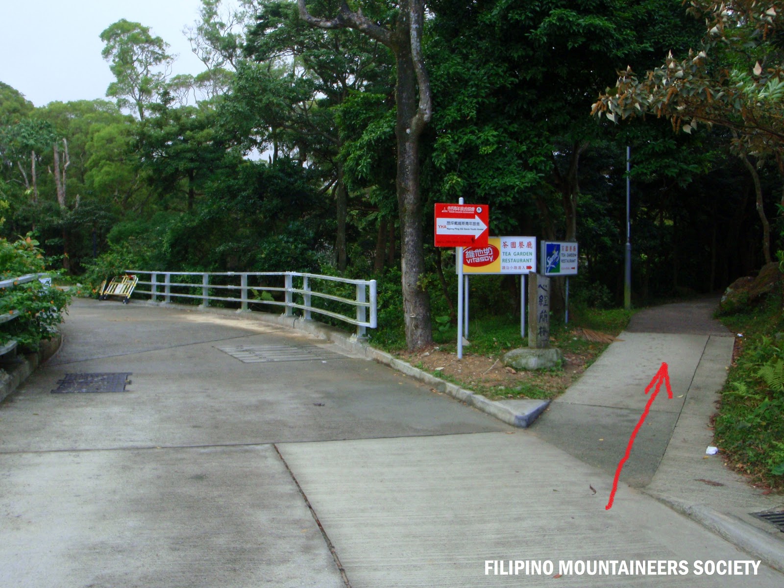
A Fork
Take the route to the right and locate the weekend Garden Tea House
(They serve vegetarian dishes as well)

Turn Left and in just minutes, you will see the Garden Tea House.

Pass the Garden Tea House and you'll get to this fork, choose the left side from here. If you wanna take a little bit more adventure, take the right side and you will see the Wisdom Path & Phoenix statue. Then from there you can take the route on the left side of the board map/info. 

Whichever path you choose...it will eventually lead you towards this area.
The Nei Lak Shan main entry point.

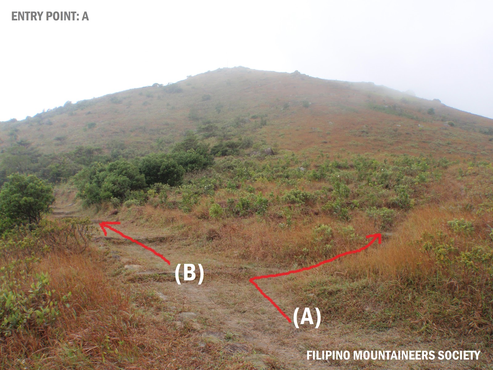
After a few minutes of hike, you will see this fork again! As you can see, there's a tiny Trail Board Map on the right side (this will serve as your Entry & Exit Point) go on have a look and probably take a photo of the map for future references.

Eventually, whichever you choose here will serve as Entry/Exit area. In this case I took the route (B) and locate the Nei Lak Shan Viewing Compass.

Here is the Viewing Compass at Nei Lak Shan and it will serve as your
starting area to go uphill and summit Nei Lak Shan.
(The location where I'm standing while I took this photo is the exact area to begin your ascend).  

As I mentioned earlier, the trail is 95% natural...I meant this!
Be cautious during wet season as it gets to slippery up here.

(working on my way up at the summit...)

This is the Summit Marker of Nei Lak Shan.

Please pay serious attention on this warning sign which is erected along the trail because there's an electricity buried underneath the ground and it is said to be very high in voltage...so beware!

The red arrow is pointing at your safe-way and the location where you can end your adventure.

Take the route to the left and it will lead you back the Tiny Trail Map.

Here it is "Tiny Trail Map"...simply follow the arrow to the right and you will end at the Nei Lak Shan Main Entry Point. There are two options to finish your adventure here (if your up for another hour of extended adventure), the first is to return to Po Lin Monastery and board the NLB 23 to Tung Chung Station or head downhill on the left side & enter the (Blue color) gateway to Lo Hon Monastery (Ngong Ping Trail) and if you reached the residential area at Shek Mun Kap, then take the mini bus 35 to return to Tung Chung Station.


Friendly Reminder
Enjoy Your Country Park, Enjoy Hiking and Leave No Trace!