- Wherever you are in Hong Kong, just take the MTR and head on to TUNG CHUNG MTR STATION.
- At Tung Chung MTR Stations, take Exit A and locate the BLUE TAXI Terminal on the left-side of the Exit A, passing the RED TAXI Terminal (Note: Red Taxi are "NOT" allowed to give service to travelers around Lantau Island...only BLUE! Because Red Taxi are only allowed in KOWLOON AND HK ISLAND).
- So, Take the Blue Taxi to Wong Lung Hang Road and you need to get to "TEI PO NEW VILLAGE" until you reach the Gate Barrier...it should cost atleast HK$35 (for a maximum of 5 person inside the Taxi). Better than walking from Tung Chung Station to the Gate Barrier that would take around 45mins to 1 hour.
TRAIL INFO:
- (LOOP TRAIL)
- 80% Wetland & Rockies
- 20% Dry Land
- Duration: 3 Hours IN & 3 Hours OUT (Non-Stop Loop), 7-7 1/2 if you take the Most Difficult & Boring Trail uphill which will lead you up to Sunset Peak Trail and from there, you can choose to end at Mui Wo (1 hr again) to get you to central (another hour), or ending it at Pak Kung Au (1.5hr) then take the bus to Tung Chung (35-40mins ride).
- Difficulty: If you just do the loop (IN & OUT) the rating is 4/5. But if you take the the trail all the way up to Sunset Peak which may involve "Low level of ROCK CLIMBING"...it should be 5/5 rating.
(Note: Be prepared to get WET!)
LOGISTICS:
- 18L to 20L Packs (Pack that will keep everything dry)
- 2L Of Water (H2O)
- 1L of Energy Drink
- Food (Must because the trail is around 3 hrs in and 3 hrs without stopping)
- Mini 1st Aid Kit (Hope u won't need 'em...but bring it!)
- Pair of Wet Wear
- GoPro Cam or Any Water-Resistant Camera
- Cellphone (Good coverage inside the stream but be sure to protect it from getting wet).
- A good pair of water-shoes or toe protected sandals.
LET'S GO!
 |
| BARRIER GATE Taxis are not allowed to get inside this section anymore so you need to walk from here. |
 |
| FRIENDLY SIGNAGE The easy concrete path is filled with easy to locate directions signage like this one. |
 |
| SMALL BRIDGE Just simply go and pass through it... |
 |
| WONG LUNG HANG PICNIC SITE If you came here for such reason then you should stop here. But your target is something else ...so please proceed along the Red Markings. |
 |
| Neither Left or Right....Just walk straight ahead! |
 |
| END OF THE ROAD There's a water contraption on the right side of the tunnel and you will need to get to the left side of the slope and head towards the stream which is too obvious to find. Get down on the mini stairs and immediately you'll set foot on the Rockies. |
 |
| WATER CONTRAPTION / DAM This is the starting point of the stream! Option 1 (Red): Make your way up the ladder and pass thru the railings and immediately get down into the stream on the right-side of the railings. Options 2 (Yellow): Directly make your way thru the stream by taking a swim thru the pool. |
 |
| (VIEW ON TOP OF THE DAM) Option 1 will lead you on the side of the stream if you really don't know how to swim or if you wish not to get wet early. But Option 2 will surely give you that adrenaline rush because you seek the adventure! |
 |
| Here is what it looks like when you take the ladder up and immediately go down on the right-side to walk along the stream. |
 |
| Here are some highlights of the stream... |
 |
| A FORK Don't get confused...simply turn on the right-side from here and proceed upstream! |
 |
| Another POOL Take a dip here if you wish but be cautious if you jump in. |
 |
| This is the best place to have a break and take that power meal...when your done, remember to follow this clearly marked bearing point (up and over the 2 huge rocks) up stream. |
 |
| I highly chose and recommend this area for a lunch break because u can sit in the water as you enjoy your home-made meal. (I usually cook on the trail, bringing-in my home-made alcohol stove and my favorite spicy instant noodles) |
 |
| 1st Waterfall What a refreshing rewards isn't it? Go ahead and swim or take a plunge if you must! (Note: The water here is very clear so you should be able to see where exactly you can jump...be careful!) |
 |
| TRAIL CHALLENGER After that great moment in the waterfall, it's now time to Climb! This sections has some rope ready to help you uphill but at as the saying goes..."Never put your life at risk on the work of a stranger!". Never use the rope as your primary tool of climbing uphill, use your hands and feet, grab some trees and rocks if time comes grab the rope but secure yourself first before putting 30% of your weight into it. |
 |
| 2nd Waterfall Immediately after the climb...you will soon encounter this subtle and yet satisfying waterfall. Go ahead and jump in! |
 |
| LEFT DRAGON WATERFALL |
 |
| RIGHT & TAIL DRAGON WATERFALL When you reach this section...you are now done with your loop trail! Make your way back to where you started and just simply walk all the way to Tung Chung MTR Station. |
 |
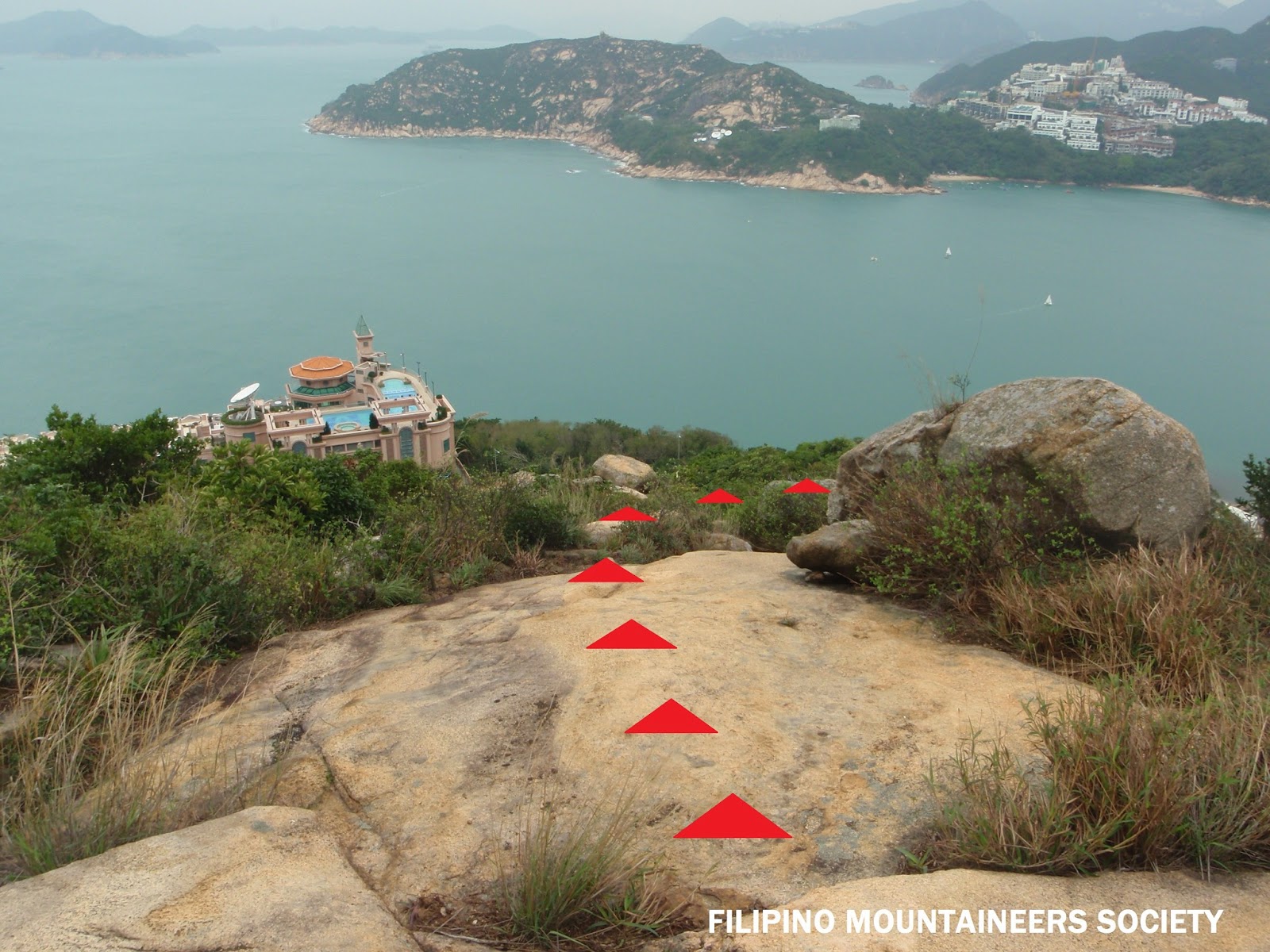
| STILL LOOKING FOR MORE? Well, this section is no longer advisable to all intermediate level Hikers! Only the most Extreme Hikers should continue this section because it has a Low Level of Rock Climbing involved. You won't find any Waterfalls from here...which means...all business and less pleasure! You can proceed uphill by keeping your path / bearing towards Mui Wo, climb up at the side of the stream (there should be a ribbon along the side of the trail). Again, just a reminder! there is no turning back when you take this section of the trail because there will be a low-level rock-climbing and there's no turning back in the middle of the trail. Some rope are there to assist you but then again...you are putting your life at risk on some strangers set-up. At times, you might feel that you are lost in the woods but bear in mind that you need to climb uphill and eventually hit a trail...remember your that your navigation point is Sunset Peak via Lin Fa Shan Trail. When you reach top and saw a trail milestone...it is about 5.5km of downhill hike towards Mui Wo via Nam Shan Trail. (If your in doubt about the remainder of this section...just GO BACK!). For those who wish to proceed...Be Safe & Good Luck! Friendly Reminder Enjoy Your Country Park, Enjoy Hiking and Leave No Trace! |